Wednesday, February 28, 2018

BLM Glamping south of Poncha Pass

Uma, Fiona and I displaced from the Turtle Rock BLM Campground this morning and ended up at another BLM site just off of US285 and south of Poncha Pass.

I'd seen an RV here before while riding around, the last time I was in the area, and I parked Uma basically in the same spot where I'd seen the other RV.

Couldn't go much further into the BLM area as the dirt trail had many sections that were snow-packed and I am pretty sure that's territory to be avoided with this particular motor home.  Now, if I had one of those pricey Overlander RVs....but that's a different story.

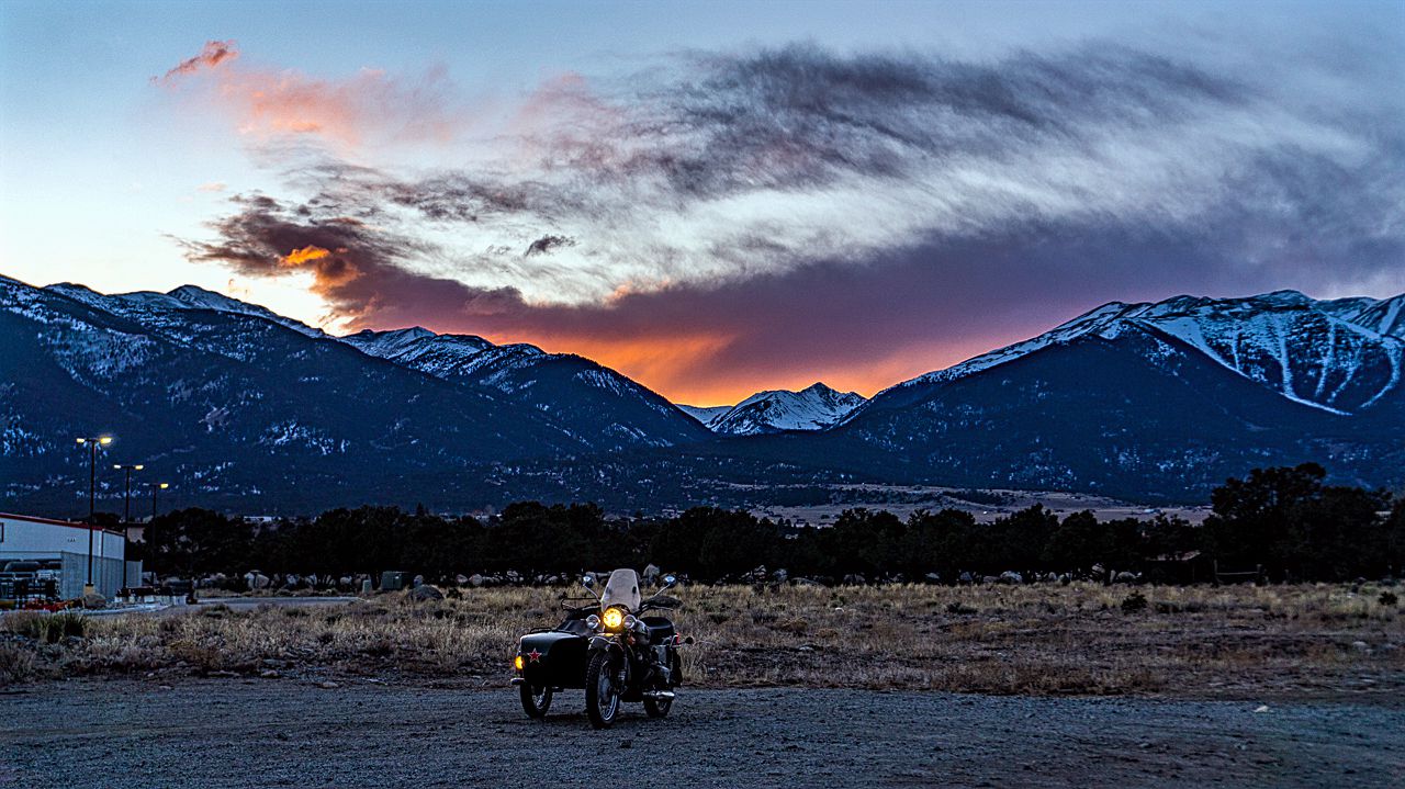
During lunch, and before the clouds that threatened snow moved in, I rode out on Fiona for some pics of the Sangre de Cristo (Blood of Christ) mountains.


Then it started to snow, very slightly, so back to the RV I went as it got quite cold and Fiona lacks any heating gear except for her engine.

The snow fall wasn't much of anything, and soon the sun came out again.


The afternoon came and went, lots of cloud activity and a brisk wind keeping things at the freezing point on the thermometer.

You can see the peak of Mt. Shavano from this location

Not much of a sunset either for today, here's the best I could do.


Tomorrow its off to CaƱon City, to a campground near the Royal Gorge Bridge.


Tuesday, February 27, 2018

Boondocking in Buena Vista

Next few days, checking out new boondocking sites, to see how well they fit my present work/play requirements.

Tried out a piece of land belonging to a neighborhood friend.  The property is in the Indian Head Mountain community but cellular coverage proved weak.  All I could get was extended 3G, four bars, but basically unusable for work.

Moving on then along US Highway 285, I arrived once again at Buena Vista and elected to stay in the same spot as before in the Turtle Rock BLM campsite.  I believe I have the whole place to myself, go figure, campers tend to not camp in Winter.  

It's going to be a warmish week so it's warm enough for me while the sun is out!  It was in the low 40s as I rode along CR 375, checking out other boondocking camp sites but not finding any suitable for Uma, the URRV.

 Part of the Collegiate Peaks in the background

This view was by the gate to the Four Mile Ranch, which
is for sale.  I left a VM with the realtor asking what the price was.
(update: owner is asking $495K)

I then headed into BV: Buena Vista and fueled Fiona up and then tried for some sunset shots at the usual spot.   Nothing much there, ended up taking the last couple of pics near the gas station!


 That's Birthday Peak in the middle, with Mt Yale on the left
and Mt Columbia on the right


I'm going to check out the BLM/National Forest spots one can see from US285 as one approaches from the east to see what kind of cell reception they have tomorrow.  Then, I might stay another day or move a little further down to some BLM spots I'd spotted south of Poncha Pass, we'll see.

Saturday, February 24, 2018

Uraling in the South Valley Park

It was time for Fiona, my '99 Bural Patrol to get some much needed exercise.

She'd not really been ridden for the whole time I was in NM/AZ you see; but today that was remedied.

We rode out of the neighborhood and stopped for an hour or so near the junction of Santa Fe Road and C-470.  There was some work to do at the Cyxtera Data Center there so I wouldn't have to do it on Monday.

After the task was complete, we rode onto Deer Creek Canyon Road which one accesses via Wadsworth Blvd exit off of the C-470 highway.

First a stop at the neighborhood which surrounds Deer Creek Canyon Park for the usual view of nearby rock formations:


We then started heading west back on Deer Creek Canyon Rd but didn't get very far into the canyon itself; ran out of gas you see at 169 km on the trip meter.

I usually start looking for gas around 160 and usually only required 4 gallons so I thought I had the range, but nope.  Luckily, had about a gallon of gas in the spare gas can and I headed back towards Santa Fe boulevard and the nearest gas station.

Topped off this time, we went back towards Deer Creek Canyon and rode it all the way to the end where it junctons with Turkey Creek Road.  We reversed course and rode back towards South Valley Park to check out its many scenic rock formations:


As we exited back towards the metro area, I stopped to take a picture of the power line towers....they reminded of the Free French Cross and the way one pair was painted light blue somehow caught my eye.


As you can see, no snow on the roads; even in the twistier bits of road in the canyon.  The shady areas of the canyon were perhaps 2-3 degrees cooler and you can feel it in your fingertips in spite of heavy gloves.

Took the back way, via Waterton Canyon road back to Santa Fe Road aka US85.  I then took County Line road eastward back to my home neighborhoods.  It was a pretty windy day for a ride with temperatures starting just below freezing and soaring to almost 37°F (2.7°C) under sunny conditions.

Tuesday, February 20, 2018

Winter Conditions at Last

It's been a very mild winter so far, that I've experienced anyways.  Spending a month down in NM/AZ didn't help of course.

Yesterday it started to lightly snow but no real accumulations during the President's Day holiday.  It continued snowing overnight though and we woke to perhaps 2" of snow here in the SE portion of the Denver Metro area.

Rode out just before lunch after getting some work done and enjoyed cold temperatures that stayed mostly around 12°F (-11°C) the whole time I was out.  It would get 2 degrees cooler a bit further to the SE but it also produced good conditions for Hoar Frost on the trees there.

The only negative was low clouds to the west obscured the Front Range mountains completely!  Still, I think you'll agree it was good riding conditions.

 At the parking lots of Eaglecrest High School

 It was a bit colder here in the ranching neighborhood
I like to frequent for pictures


Got home with toes slightly chilled within my riding boots but otherwise no real problem with the cold conditions.  I know, for RichardM in AK, these conditions would have been balmy but for me, it was cold enough.  :)

Sunday, February 18, 2018

Published in Sidecar-Traveller Magazine

Sidecar-Traveller magazine's Martin Franitza asked me late last year to use one of my Thanksgiving Day pictures in the February 2018 issue.


It's the first double-page on the magazine:


This is the original photo:


There was no renumeration for this, but I figure, exposure is a good thing.


Friday, February 16, 2018

Uraling to a Volcano

This morning, it was a "brisk" 22°F (-5.5°C) in Capulin, New Mexico at the RV Park where I'd spent the night.

As I was waiting for temperatures at Raton Pass (at the border with Colorado) to be above freezing before I drove the pass; it was time for a visit to the Capulin Volcano National Monument.

It had been quite foggy as I rode to the volcano, in fact, so foggy you couldn't even see it as you approached it.  This fog or low flying clouds obscured things quite thoroughly at the summit as well.

I was the first one at the visitor center, and once they opened I paid the $10 for a motorcycle fee and waited a few more minutes while they "checked" the road before opening it up to the public.

You can ride all the way to a parking lot at the summit of the volcano's rim; but the road while paved is not replete with safe spots for stopping for pictures.

It was basically like being on the top of a hill, surrounded by fog and nothing but gray fog looking down from the path which circles the rim of the volcano.

 A fleeting glimpse of a nearby peak as the clouds
blew past me on the volcano rim

As I waited for the fog to burn off or the clouds to blow on through, I took some pictures of the bushes which were nicely covered with hoar frost.

 Telephoto shot of the trees on the opposite side of the rim


 For a few seconds, you could see the parking lot from 
the top, this should give you an idea of the height gained


Close to 9:00 AM the clouds cleared or the sun burned off the fog and I was able to see the surrounding landscape.

 Same viewpoint as the first pic, this time without clouds
hiding the intervening valley


 Above is the small town of Capulin, about three miles away

 I think the small volcano is called Baby Capulin

My photos of the volcano's crater or plug didn't turn out either due to the fog or it's lack of any real features besides the trail you can walk down to it's bottom.  It was "unremarkable" in my view.

 A view of the valley on the way back down

A pic of the volcano from the entrance....

That's it, not a bad stop if you're enroute to Raton, NM or points east in Texas.

Oh, and I am back home in the great and getting much overcrowded state of Colorado

Thursday, February 15, 2018

Driving to a Capulin, New Mexico Sunset

Long day on the road, woke to low overcast and rainy skies near Elephant Butte, NM where I'd spent the night boondocking.

The weather being gray and wet, I elected to keep going north instead of trying to find a BLM near the Very Large Array radio-telescope dish farm about an hour west of Socorro, NM.

So I ended up driving on I-25 till I got to Maxwell, NM and the Wildlife Refuge Area there that allstays.com listed as an all year facility.  No so, it's only open for camping from end of May to end of Oct according to the lady who answered their office phone.  Oh well.

Instead I displaced to nearby Capulin, New Mexico to spend the night at a modest RV Park.  Tomorrow morning, I'll be hitting the entrance to the Capulin Volcano National Monument and riding Scarlett as far up as I can up the volcano.  Should be interesting and I hope, photogenic.

In the meantime, once I settled into the RV park (of which I'm the sole occupant), I rode out with Scarlett to catch the sunset.  Sunsetwx had declared it to be a nogo but they were wrong, again.